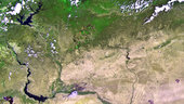
The recently launched Proba-V miniaturised satellite captured this image over the border region of northern Syria, southeastern Turkey and northern Iraq on 28 May. The area pictured is about 500 km across, with large reservoir lakes along the Euphrates River visible on the left, and another along the Tigris River on the right. In the central-right portion of the image, we can see Iraq’s Sinjar mountains. Proba-V will map land cover and vegetation growth across the entire planet every two days with its Vegetation imager. In this image, the contrast between the green areas – some with agricultural plots – and the sparsely vegetated areas is evident. It demonstrates Proba-V’s ability to see slight differences in vegetation cover. Vegetation intensity and health can help in crop yield predictions and to map interannual changes in vegetation cover.
This image is featured on the Earth from Space video programme.