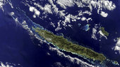
The New Caledonia archipelago, 1210 km east of Australia, is captured in this Envisat image, acquired on 5 July 2011. The main island, Grande Terre, dominates the image, stretching 350 km long from northwest to southeast. A mountain range runs the length of the island – its highest point reaching over 1620 m – and divides the land’s lush east from the savannahs in the west. A coral reef surrounds the main island and stretches into the Coral Sea to the northwest. The reef provides an important nesting site for green sea turtles and is home to endangered dugongs.
This image is featured on the Earth from Space video programme.