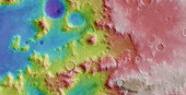
This colour-coded plan view is based on an ESA Mars Express HRSC digital terrain model of the region, from which the topography of the landscape can be derived. The colour coding enhances the visibility of the rippling sand dunes which formed in the wind-sheltered sides of the mounds and canyons. Centred at around 40°S and 310°E, the image has a ground resolution of about 23 m per pixel. Taken during revolution 10736 on 6 June 2012.