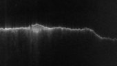
A radar view of the southern highlands of Mars, captured by the Mars Advanced Radar for Subsurface and Ionospheric Sounding (MARSIS) instrument on ESA’s Mars Express. The radar track covers 5580 km and features the Hellas Basin at the far right, and the south polar ice cap with its associated layered deposits just left of centre.
The gap to the left of the south pole is an artificial effect due to a distortion in the measurements; it does not correspond to any geological feature.
The image was first highlighted by The Planetary Society’s blogger Bill Dunford, in his Exploring ten years’ worth of Mars Express Data entry featured in June.