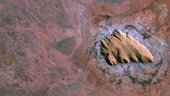
Uluru/Ayers Rock in the Australian outback is featured in this image from the Kompsat-2 satellite. The rock formation is anInselberg– German for ‘island mountain’ – a prominent geological structure that rises from the surrounding plain.
Hundreds of millions of years ago, this part of Australia was a shallow sea. Layers of sandstone settled on the ocean floor and were compressed. These hardened, horizontal layers were uplifted and tilted almost 90º upwards to their present position. The rock eroded slower than the surrounding softer deposits until the monolith stood high above an otherwise flat surface. From this perpendicular angle of the satellite acquisition, we can see those layers that were once horizontal and now appear to cut across the top of the formation.
The Korea Aerospace Research Institute’s Kompsat-2 satellite acquired this image on 15 September 2011. ESA supports Kompsat as a Third Party Mission, meaning it uses its ground infrastructure and expertise to acquire, process and distribute data to users.
This image is featured on the Earth from Space video programme.