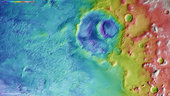
Colour-coded topography map of a region of the Argyre basin, featuring Hooke crater and part of the floor of the basin known as Argyre Planitia. White and red show the highest terrains, while blue and purple show the deepest. The image is based on a digital terrain model of the region, from which the topography of the landscape can be derived. The region clearly slopes to the south (left).
The image was acquired by the High Resolution Stereo Camera on Mars Express on 20 April 2014 during orbit 13 082. The ground resolution is about 63 m per pixel. Hooke crater is located at about 46°S / 316°E. North is right and East is down.