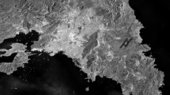
Greece’s Attica peninsula, with the capital and largest city of Athens appearing bright white near the centre, is captured in this radar image from Sentinel-1A on 22 April.
Athens sits on the region’s central plain and is surrounded by four large mountains, the tallest being Mount Parnitha to the north standing over 1420 m. Much of the mountain is a national park, but suffered extensive damage during the 2007 wildfires that swept the country.
In the left side of the image, bright radar reflections from ships speckle the Saronic Gulf near port cities, most notably Greece’s main port of Piraeus.
On the right, the runways of the Athens airport are evident. Smooth surfaces like airport runways or water appear dark in radar images, making them easy to identify – such as the U-shaped Marathon Reservoir in the upper right. This makes radar especially suited for identifying water resources or to monitor flood extent – information useful for emergency response efforts.
This image, also featured on the Earth from Space video programme, was acquired by Sentinel-1A’s radar in ‘interferometric wide swath’ mode, the default mode over land, which has a swath width of 250 km and a ground resolution of 5 x 20 m.
As part of the activities for European Researchers’ Night, ESA is holding a special event in Athens on 26 September at the National Center for Scientific Research “Demokritos”.
Researchers’ Night aims to increase awareness of European researchers and their work. At this year’s event, people of all ages can learn more about the world of space science and hear a special message from astronaut Paolo Nespoli.