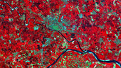
A close-up of an area in the Po Valley – showing Pavia (centre) and the confluence of the Ticino and Po rivers – is a subset from the first image from the Sentinel-2A satellite acquired on 27 June 2015 at 10:25 UTC (12:25 CEST), just four days after launch. Processed using the high-resolution infrared spectral channel, the satellite’s instrument will provide key information on crop type and health, assisting in food security activities.