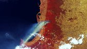
ESA’s Proba-V minisatellite caught sight recently of this enormous smoke plume from a bushfire raging south of Perth in Western Australia.
This 300 m-resolution false-colour image, acquired on 7 January, shows smoke extending over Geographe Bay into the Indian Ocean. The smoke can be differentiated from the clouds also seen in the image by its blue–grey tint.
Bushfires are frequent events during the long, dry Australian summer. Certain native fauna, such as eucalyptus trees, have evolved to survive such bushfires, but the fires can cause substantial property damage and threaten lives. In this case, several hundred houses and an area exceeding 700 sq km had burnt down by 13 January.
Launched on 7 May 2013, Proba-V is a miniaturised ESA satellite tasked with a full-scale mission: to map land cover and vegetation growth across the entire planet every two days.
Its main camera’s continent-spanning 2250 km swath width collects light in the blue, red, near-infrared and mid-infrared wavebands at 300 m resolution and down to 100 m resolution in its central field of view.
VITO, the Flemish institute for technological research, processes and distributes Proba-V data to users. VITO has produced an online gallery highlighting some of the mission’s most striking images so far, including views of storms, fires and deforestation.
Next week sees a major symposium devoted to the minisatellite and its global output, taking place at Ghent in Belgium.