Launched on 7 May 2013, Proba-V is a miniaturised ESA satellite tasked with a full-scale mission: to map land cover and vegetation growth across the entire planet every two days.
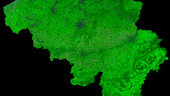
This cloud-free image of Belgium, acquired by Proba-V on 19 July 2015, has a 300 m per pixel resolution and is composed of cloud, shadow, and snow/ice screened observations over a period of 10 days.
Belgium is one of ESA’s 22 member states.
Proba-V imagery at 1km resolution is owned by ESA, Proba-V imagery at 300m resolution is owned by Belspo, the Belgian Science Policy Office.
VITO Remote Sensing processes and distribute Proba-V data to users worldwide on behalf of ESA and Belspo.
This image is part of a set to celebrate the launch of ESA’s new Open Access (OA) policy for images, video and data: 22 freshly processed and thus new images of ESA’s 22 member states have just been released under the OA compliant Creative Commons CC-BY SA 3.0 IGO licence. The set consists of one cloud-free image in 300 m per pixel resolution of each ESA member state, i.e. Austria, Belgium, the Czech Republic, Denmark, Estonia, Finland, France, Germany, Greece, Hungary, Ireland, Italy, Luxembourg, the Netherlands, Norway, Poland, Portugal, Romania, Spain, Sweden, Switzerland and the United Kingdom.
Credit: ESA/Belspo – produced by VITO, Creative Commons CC BY-SA 3.0 IGO