|
Target: Earth Instrument: InSAR Image Credit: NASA/JPL-Caltech/Rutgers University |
Click here for original story, PIA25527: Map of New York City Subsidence and Uplift
Source: NASA Earth Images
|
|
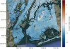
Target: Earth Instrument: InSAR Image Credit: NASA/JPL-Caltech/Rutgers University |
Click here for original story, PIA25527: Map of New York City Subsidence and Uplift
Source: NASA Earth Images