Top of page
A new satellite that one Environment and Climate Change Canada researcher calls “revolutionary” will unlock secrets of oceans, lakes, and rivers, from coast to coast to coast – including in remote areas, normally too difficult or expensive to reach.
Surface Water and Ocean Topography (SWOT) is a joint mission with the Canadian Space Agency’s partners in the U.S. (NASA) and Europe (CNES, UKSA), containing Canadian-made technology. This sophisticated satellite will collect data on 90 per cent of Earth’s surface water – a surface we’ve barely scratched!
Of course, Canada is blessed with an abundance of water, meaning this country will reap the benefits. Experts will have access to detailed data, to guide important decisions on climate change, marine habitats, shipping, flooding, spill containment, search and rescue, hydropower, fisheries, and more.
We’ve selected five important regions for science and conservation to profile on our blog.
Hecate Strait
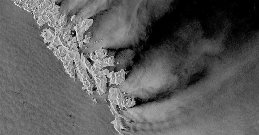
The southern part of the Haida Gwaii archipelago from space, with the Pacific Ocean at left, and the Hecate Strait at right. (Credit: European Union – Copernicus Program, contains modified Sentinel-1 data processed by Sentinel Hub)
The strait is a shallow waterway between the archipelago of Haida Gwaii and British Columbia’s Pacific coast. It’s a busy corridor for ships, and home to an underwater oasis.
The diverse marine ecosystem supports a vibrant habitat for fish species like Pacific salmon and a rare “glass sponge” reef, which formed after the last ice age and is as tall as an eight-storey building in some places. The Hecate Strait and Queen Charlotte Sound were recently designated a Marine Protected Area.
Currently, a network of instruments measures ocean currents, sea levels, water temperature and salinity. Alone, their reach is limited, but when combined with SWOT‘s view from space, oceanographers will get a comprehensive picture of Canada’s West Coast.
Peace–Athabasca Delta
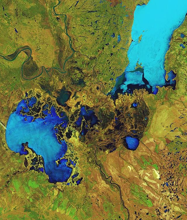
The Peace–Athabasca Delta from space. (Credit: ESA)
The delta formed at the convergence of two rivers and mostly falls within Canada’s largest national park, Wood Buffalo, in Alberta. It’s also a UNESCO World Heritage Site, recognized for its migratory birds and wild bison.
This unique ecosystem, with its wide range of conditions, from floods to droughts, has sustained Indigenous communities for centuries. The delta’s complex network lakes, rivers, and wetlands makes it the perfect playground for SWOT to show us what it can do.
Given that it’s such a vast territory, it’s difficult to study the entire delta with fieldwork alone; SWOT will change this by giving hydrologists an unprecedented look at the whole area from space.
North Saskatchewan River
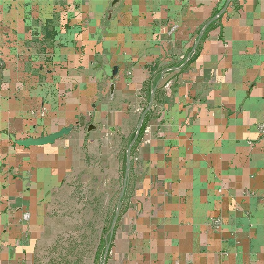
The North Saskatchewan River from space. (Credit: European Union – Copernicus Program, contains modified Sentinel-2 data processed by Sentinel Hub)
The river flows from the Rockies, through the Prairies, to Hudson Bay. It is an important artery for electricity, feeding several large hydro plants, and for drinking water, as Edmonton’s sole water supply.
Through the Prairies, it has a low slope, meaning it’s quite flat with little variation in elevation along the river. More than any other site, this will test the limits of the satellite, and its ability to measure the most minute changes.
To ensure the most accurate measurements possible, hydrologists are setting up corresponding ground-level stations, to compare notes with SWOT‘s data from space.
Manicouagan Reservoir

The Manicouagan Reservoir from space. (Credit: European Union – Copernicus Program, contains modified Sentinel-2 data processed by Sentinel Hub)
The reservoir is a large inland lake in Quebec, clearly visible from space, formed by a meteorite impact millions of years ago. Today, it’s an important site for power generation.
SWOT will help the hydro utility harness the reservoir’s full, electrifying potential! The generating stations are accessible by road, but other areas are challenging to reach, and might require a helicopter, for example.
Taking water measurements at the main sites doesn’t paint the whole picture, because conditions vary across the reservoir, which is sensitive to fluctuations in wind and pressure. The satellite will measure the entire reservoir level at once, for the first time.
St. Lawrence Estuary

The mouth of the St. Lawrence River from space. (Credit: CSA/NASA)
The estuary is one of the world’s largest, where fresh and saltwater collide, as the mighty St. Lawrence River flows into the gulf. The river is a vital shipping corridor for Canada and the United States.
Researchers will use SWOT to measure tidal patterns, starting with the area between Quebec City and Rimouski. Their work will help ships navigate, contain oil spills, and protect endangered North Atlantic right whales.
The St. Lawrence is very wide, and tides can vary across the river, so until now, scientists were limited to predictive models. The satellite will allow them to measure the entire waterway for the first time.
Explore further
- Date modified: