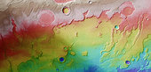
The transition between Acidalia Planitia and Tempe Terra in a colour-coded plan view based on a digital terrain model of the region, from which the topography of the landscape can be derived. Note the variance in depth between the older craters at the top of the image and the younger smaller craters to the lower part. Centred at around 37°N and 306°E, this image has a ground resolution of about 15 m per pixel. The upper craters are believed to have once held liquid water and have been subsequently filled in by sediments.